he clockwise warm-water
North Atlantic Gyre occupies the northern Atlantic, and the counter-clockwise warm-water
South Atlantic Gyre appears in the southern Atlantic.
[5]
In the North Atlantic surface circulation is dominated by three inter-connected currents: the
Gulf Stream which flows north-east from the North American coast at
Cape Hatteras; the
North Atlantic Current, a branch of the Gulf Stream which flows northward from the
Grand Banks; and the
Subpolar Front,
an extension of the North Atlantic Current, a wide, vaguely defined
region separating the subtropical gyre from the subpolar gyre. This
system of currents transport warm water into the North Atlantic, without
which temperatures in the North Atlantic and Europe would plunge
dramatically.
[33]
In the subpolar gyre of the North Atlantic warm subtropical waters are
transformed into colder subpolar and polar waters. In the Labrador Sea
this water flows back to the subtropical gyre.
North of the North Atlantic Gyre, the cyclonic
North Atlantic Subpolar Gyre
plays a key role in climate variability. It is governed by ocean
currents from marginal seas and regional topography, rather than being
steered by wind, both in the deep ocean and at sea level.
[34] The subpolar gyre forms an important part of the global
thermohaline circulation. Its eastern portion includes
eddying branches of the
North Atlantic Current
which transport warm, saline waters from the subtropics to the
north-eastern Atlantic. There this water is cooled during winter and
forms return currents that merge along the eastern continental slope of
Greenland where they form an intense (40–50
Sv) current which flows around the continental margins of the
Labrador Sea. A third of this water become parts of the deep portion of the
North Atlantic Deep Water (NADW). The NADW, in its turn, feed the
meridional overturning circulation
(MOC), the northward heat transport of which is threatened by
anthropogenic climate change. Large variations in the subpolar gyre on a
decade-century scale, associated with the
North Atlantic Oscillation, are especially pronounced in
Labrador Sea Water, the upper layers of the MOC.
[35]
The South Atlantic is dominated by the anti-cyclonic southern subtropical gyre. The
South Atlantic Central Water originates in this gyre, while
Antarctic Intermediate Water originates in the upper layers of the circumpolar region, near the
Drake Passage
and Falkland Islands. Both these currents receive some contribution
from the Indian Ocean. On the African east coast the small cyclonic
Angola Gyre lies embedded in the large subtropical gyre.
[36] The southern subtropical gyre is partly masked by a wind-induced
Ekman layer. The residence time of the gyre is 4.4–8.5 years.
North Atlantic Deep Water flows southerward below the
thermocline of the subtropical gyre.
[37]
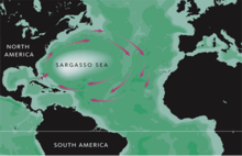
Sargasso Sea
Approximate extent of the Sargasso Sea
The Sargasso Sea in the western North Atlantic can be defined as the area where two species of
Sargassum (
S. fluitans and
natans) float, an area 4,000 km (2,500 mi) wide and encircled by the
Gulf Stream,
North Atlantic Drift, and
North Equatorial Current. This population of seaweed probably originated from Tertiary ancestors on the European shores of the former
Tethys Ocean and has, if so, maintained itself by
vegetative growth, floating in the ocean for millions of years.
[38]
Sargassum fish (Histrio histrio)
Other species endemic to the Sargasso Sea include the
sargassum fish, a predator with algae-like appendages who hovers motionless among the
Sargassum. Fossils of similar fishes have been found in fossil bays of the former Tethys Ocean, in what is now the
Carpathian
region, that were similar to the Sargasso Sea. It is possible that the
population in the Sargasso Sea migrated to the Atlantic as the Tethys
closed at the end of the Miocene around 17 Ma.
[38]
The origin of the Sargasso fauna and flora remained enigmatic for
centuries. The fossils found in the Carpathians in the mid-20th century,
often called the "quasi-Sargasso assemblage", finally showed that this
assemblage originated in the
Carpathian Basin from were it migrated over
Sicily to the Central Atlantic where it evolved into modern species of the Sargasso Sea.
[39]
The location of the spawning ground for European eels
remained unknown for decades. In the early 19th century it was discovered that the southern Sargasso Sea is the spawning ground for both the
European and
American eel
and that the former migrate more than 5,000 km (3,100 mi) and the
latter 2,000 km (1,200 mi). Ocean currents such as the Gulf Stream
transport eel larvae from the Sargasso Sea to foraging areas in North
America, Europe, and Northern Africa.
[40]


No comments:
Post a Comment